


Home Reference Census Records Military African-American Other States New Titles E-BOOKS FREE SHIPPING IN USA The Growth of Virginia in Maps, 1634-1895:Introduction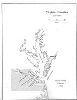 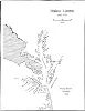 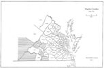 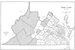 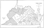 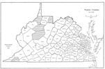 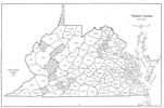 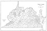 During the more than four centuries of Virginia’s existence, the Commonwealth has been transformed physically numerous times. From a broad, amorphous claim in the beginning stretching to the Lake of the Woods, western lands eventually were trimmed away. By 1792 the familiar shape of Virginia (with West Virginia still attached until the 1860s) began to emerge. But within this new defining shape, counties continued to be born, as settlers petitioned for a county seat closer to their residence. Huge counties in the west were subdivided, while counties in the mid-section of the state and the area around the District of Columbia also saw adjustments to their boundaries. This process continued in Virginia and West Virginia until 1895. The importance of understanding county boundary alterations for genealogists is obvious. For example, it is possible for a person born in Orange County, Virginia in 1738, who passed away in 1824, lived and died in his own home without moving, to be recorded in records of Orange (1734), Augusta (1745), Botetourt (1770), Fincastle (1772), Montgomery (1777), Giles (1806), and Logan (1824) counties. Although this is an extreme example, county boundary changes were occurring continuously around the citizenry who moved away from the initial Chesapeake settlements of the seventeenth century. Presented here in an abbreviated form are the rubrics of the changes in Virginia’s boundaries in a series of maps. They are drawn from an atlas by Michael Doran which Iberian Publishing is proud to publish.
[adapted from Michael Doran, Atlas of County Boundary Changes in Virginia, 1634-1895], available under General References
|| Other States || Genealogy Links || New Titles Copyright 2025 Iberian Publishing Company
| ||||||||||||||||||||||||||||||