


Home
Reference
Census Records
Military
African-American
Other States
New Titles
E-BOOKS
FREE SHIPPING IN USA
Iberian Publishing Company's On-Line Catalog:
The Growth of Virginia, 1634-1895
1651-1660
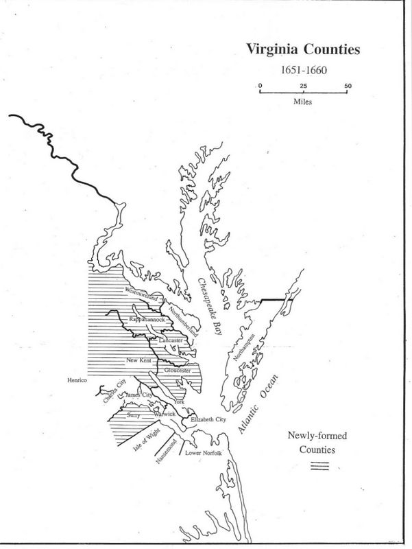
By the end of the 1640s the new settlement thrust for Virginia was into the former Chickacoan District. Northumberland and York received so many new colonists that settlers petitioned for better county services, and Lancaster and Gloucester were formed from their lands in 1651.
Further division occurred quickly. In 1653 Westmoreland was formed from Northumberland and New Kent from York; in 1656 Rappahannock was created
from Lancaster. During the 1650s the only other new county formed was Surry, out of the James City lands lying south of the James Estuary. This division occurred not because of population influx, but rather the recognition of the physical separation of the estuary. Very little activity occurred south of the James for some years, so that more than a half century would pass before further county formations were made there
1651 - Gloucester (York)
1651 - Lancaster (York, Northumberland)
1652 - Surry (James City)
1653 - Westmoreland (Norhumberland)
1654 - New Kent (York)
1656 - Rappahannock (Lancaster) Divided and extinguished in 1692.
Go to Virginia map, 1661-1670
Return to Virginia Maps Introduction page
[adapted from Michael Doran, Atlas of County Boundary Changes in Virginia, 1634-1895], all twenty-four maps available in 11x17 book form atDoran's Atlas
|| Virginia/W.Va. || General Reference || Military Records ||
|| Other States || E-Books || New Titles || Home Page || E-Books ||
Copyright 2026 Iberian Publishing Company
|