

Home
Reference
Census Records
Military
African-American
Other States
New Titles
E-BOOKS
FREE SHIPPING IN USA
Iberian Publishing Company's On-Line Catalog:
The Growth of Virginia, 1634-1895:
1841-1850

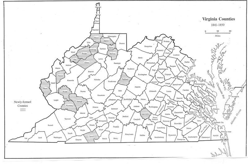
The flood tide of county formation developed during the 1840s, with the creation of seventeen counties in eight years as detailed below. Almost half of the new counties were derived from lands given up by three or more donors. Most activity continued to be on the Appalachian Plateau;
but the last major unresolved zone east of the Blue Ridge was finalized with the creation of Appomattox from Buckingham, Prince Edward, Charlotte, and Campbell. This area remained fairly wild, and it was the natural last destination of the Army of Northern Virginia in 1865 for this reason.
1842 - Marion (Monongalia, Harrison)
1842 - Carroll (Grayson)
1842 - Wayne (Cabell)
1843 - Ritchie (Harrison, Lewis, Wood)
1843 - Barbour (Harrison, Lewis, Randolph)
1844 - Taylor (Harrison, Barbour, Marion)
1845 - Gilmer (Lewis, Kanawha)
1845 - Doddridge (Harrison, Tyler, Ritchie, Lewis)
1845 - Appomattox (Buckingham, Prince Edward, Charlotte, Campbell)
1846 - Wetzel (Tyler)
1847 - Boone (Kanawha, Cabell, Logan)
1847 - Lands formerly in Fairfax county but ceded to the United States on formation of the District of Columbia were returned to become part of the City of Alexandria, March 13, 1847
1847 - Highland (Pendleton, Bath)
1848 - Hancock (Brooke)
1848 - Wirt (Wood, Jackson)
1848 - Putnam (Kanawha, Cabell, Mason)
1850 - Raleigh (Fayette)
1850 Wyoming (Logan)
Go to Virginia map, 1851-1860
Return to Virginia Maps Introduction page
[adapted from Michael Doran, Atlas of County Boundary Changes in Virginia, 1634-1895], available under General References
|| Virginia/W.Va. || General Reference || Military Records ||
|| Other States || Genealogy Links || New Titles || Home Page || E-Books ||
Copyright 2025 Iberian Publishing Company
|


