


Home
Reference
Census Records
Military
African-American
Other States
New Titles
E-BOOKS
FREE SHIPPING IN USA
Iberian Publishing Company's On-Line Catalog:
The Growth of Virginia, 1634-1895:
1801-1810
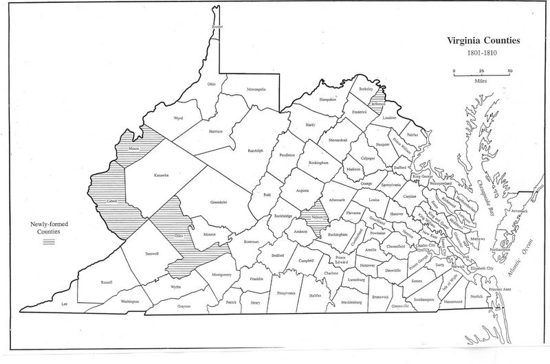
Five counties were formed within Virginia in the first decade of the nineteenth century, most in the mountainous west. In 1801 Jefferson was formed from Berkeley. this was a reflection of the importance of canal-building in opening the upper Potomac Valley to pioneering. In mid-decade, Mason formed
from Kanawha on the Appalachian Plateau, and Giles formed from Montgomery, Monroe, and Tazewell on the crest of the Alleghenies. Nelson was created out of half of Amherst just east of the Blue Ridge in 1808, and Cabell was taken from yet more Kanawha lands on the Plateau. Pioneer interest had begun to shift further west to Ohio, Kentucky, and Missouri.
1801 - Jefferson (Berkeley)
1804 - Mason (Kanawha)
1806 - Giles (Montgomery, Monroe, Tazewell)
1808 - Nelson (Amherst)
1809 - Cabell (Kanawha)
Go to Virginia map, 1811-1820
Return to Virginia Maps Introduction page
[adapted from Michael Doran, Atlas of County Boundary Changes in Virginia, 1634-1895], available under General References
|| Virginia/W.Va. || General Reference || Military Records ||
|| Other States || Genealogy Links || New Titles || Home Page || E-Books ||
Copyright 2026 Iberian Publishing Company
|