


Home
Reference
Census Records
Military
African-American
Other States
New Titles
E-BOOKS
FREE SHIPPING IN USA
Iberian Publishing Company's On-Line Catalog:
The Growth of Virginia, 1634-1895:
1851-1860
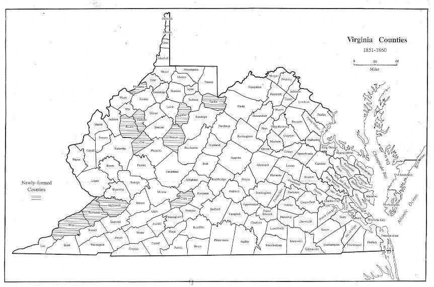
Eight out of the eleven counties formed in the decade prior to the outbreak of the War Between the States were made from lands provided by multiple donors, as is shown below. Most activity continued to be on the Appalachian Plateau, as counties began to attain sizes
adquate to provide access of their citizens to various county seats.
1851 - Craig (Botetourt, Roanoke, Giles, Monroe)
1851 - Upshur (Randolph, Barbour, Lewis)
1851 - Pleasants (Wood, Tyler, Ritchie)
1856 - Wise (Lee, Scott, Russell)
1856 - Calhoun (Gilmer)
1856 - Roane (Kanawha, Jackson, Gilmer)
1856 - Tucker (Randolph)
1858 - Buchanan (Tazewell, Russell)
1858 - McDowell (Tazewell)
1858 - Clay (Braxton, Nicholas)
1860 - Webster (Nicholas, Braxton, Randolph)
Go to Virginia map, 1861-1895
Return to Virginia Maps Introduction page
[adapted from Michael Doran, Atlas of County Boundary Changes in Virginia, 1634-1895], available under General References
|| Virginia/W.Va. || General Reference || Military Records ||
|| Other States || Genealogy Links || New Titles || Home Page || E-Books ||
Copyright 2026 Iberian Publishing Company
|