


Home
Reference
Census Records
Military
African-American
Other States
New Titles
E-BOOKS
FREE SHIPPING IN USA
Iberian Publishing Company's On-Line Catalog:
The Growth of Virginia, 1634-1895:
1791-1800
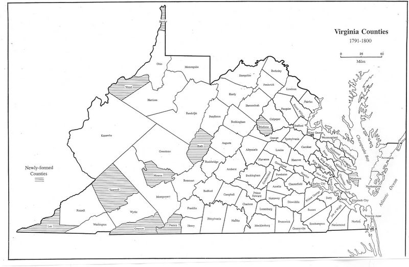
As the 1790s began, several important readjustments in the political scene of Virginia occurred. Patrick was formed from Henry, Bath from Augusta, Botetourt, and Greenbrier, and in the Tidewater the formerly sparsely-occupied portions of Gloucester were made into Mathews. In 1792, the whole set
of the counties west of the Cumberland Mountains became the State of Kentucky. In 1793 Lee was created from Russell, Grayson from Wythe, and Madison from Culpeper. In 1797 and 1798 Brooke and Wood were formed in the Appalachian Plateau from Ohio and Harrison; and in 1799 and 1800 Monroe and Tazewell came
from Greenbrier, and Wythe and Russell, respectively.
1791 - Patrick (Henry)
1791 - Bath (Augusta, Botetourt, Greenbrier)
1791 - Mathews (Gloucester)
1793 - Lee (Russell)
1793 - Grayson (Wythe)
1793 - Madison (Culpeper)
1797 - Brooke (Ohio)
1798 - Wood (Harrison)
1799 - Monroe (Greenbrier)
1800 - Tazewell (Wythe, Russell)
Go to Virginia map, 1801-1810
Return to Virginia Maps Introduction page
[adapted from Michael Doran, Atlas of County Boundary Changes in Virginia, 1634-1895], available under General References
|| Virginia/W.Va. || General Reference || Military Records ||
|| Other States || Genealogy Links || New Titles || Home Page || E-Books ||
Copyright 2026 Iberian Publishing Company
|