


Home
Reference
Census Records
Military
African-American
Other States
New Titles
E-BOOKS
FREE SHIPPING IN USA
Iberian Publishing Company's On-Line Catalog:
The Growth of Virginia, 1634-1895:
1831-1840
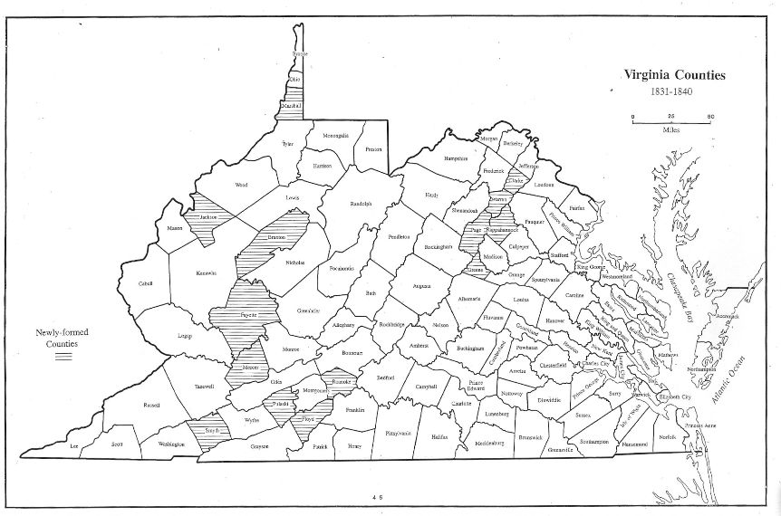
Fourteen counties were created in the 1830s, as detailed below. The majority were formed through multiple donorship of lands, and most were created on the Appalachian Plateau.
By this point the in-filling process was becoming complex and more than a little confusing to those seeking verification of land titles in county courts, for deeds valid under a jurisdiction
in one year might be monitored somewhere else the next year. Virginia's frontier zone was becoming pocked with counties in their final configuration in a nearly rndom fashion, as the surge of pioneering washed across the Appalachian Plateau.
1831 - Floyd (Montgomery)
1831 - Fayette (Logan, Greenbrier, Nicholas, Kanawha)
1831 - Jackson (Mason, Kanawha, Wood)
1831 - Page (Rockingham, Shenandoah)
1832 - Smyth (Washington, Wythe)
1833 - Rappahannock (Culpeper)
1835 - Marshall (Ohio)
1836 - Braxton (Lewis, Kanawha, Nicholas)
1836 - Clarke (Frederick)
1836 - Warren (Shenandoah, Frederick)
1837 - Mercer (Giles, Tazewell)
1838 - Greene (Orange)
1838 - Roanoke (Botetourt)
1839 - Pulaski (Montgomery, Wythe)
Go to Virginia map, 1841-1850
Return to Virginia Maps Introduction page
[adapted from Michael Doran, Atlas of County Boundary Changes in Virginia, 1634-1895], available under General References
|| Virginia/W.Va. || General Reference || Military Records ||
|| Other States || Genealogy Links || New Titles || Home Page || E-Books ||
Copyright 2026 Iberian Publishing Company
|