

Home
Reference
Census Records
Military
African-American
Other States
New Titles
E-BOOKS
FREE SHIPPING IN USA
Iberian Publishing Company's On-Line Catalog:
The Growth of Virginia, 1634-1895:
1861-1895

1861-1870:
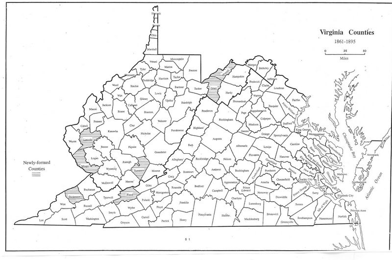
The 1860s were tumultuous years for the United States with the period of secession and civil war (1861-65) immediately followed by the early period of southern Reconstruction. Bland was created from Giles, Wythe, and Tazewell as the last antebellum county. In 1863 West Virginia was created
from several dozen Appalachian Plateau counties unwilling to be associated any longer with the secessionist Commonwelth of Virginia, and the Charleston government took over most of the responsibilities for forming new counties in their area of authority. Mineral and Grant were created in 1866 from Hampshire and Hardy, respectively, and Lincoln was made out of the lands donated by Boone,
Cabell, Kanawha, and Putnam in 1867. Berkeley and Jefferson, which had remained by choice with Virginia in 1863, were transferred to West Virginia in 1866 by fiat of the United States government in order that the lower Shenandoah Valley would be under the control of a state not expected ever to hold sympathy
with future secessionist philosophy. Although Richmond objected, nothing effectual could be done about this and the counties have stayed un the control of West Virginia.
1861 - Bland (Giles, Wythe, Tazewell)
1866 - Mineral (Hampshire)
1866 - Grant (Hardy)
1867 - Lincoln (Boone, Cabell, Kanawha, Putnam)
1871-1895:
Only a few remote areas remained to be subdivided to form new counties after the 1860s. In 1871 Summers was created from Fayette, Greenbrier, Mercer and Monroe. In 1880 dickenson was created from Russell, Wise and Buchanan, and fifteen years later Logan gave up lands in West Virginia to form Mingo in the broken country on the border with Kentucky
1871 - Summers (Fayette, Greenbrier, Mercer, Monroe)
1880 - Dickenson (Russell, Wise, Buchanan)
1895 - Mingo (Logan)
Return to Virginia Maps Introduction page
[adapted from Michael Doran, Atlas of County Boundary Changes in Virginia, 1634-1895], available under General References
|| Virginia/W.Va. || General Reference || Military Records ||
|| Other States || Genealogy Links || New Titles || Home Page || E-Books ||
Copyright 2026 Iberian Publishing Company
|


