 WYTHE CO., VA 1810 CENSUS transcribed by John Vogt. 10 1/2 x 8 1/2, x, 27 pages. This is the first surviving
census for Wythe, since both the 1790 and 1800 censuses have been lost. The transcription is in the rough alpha order of the original document for easy reference.
Wythe was an important and populous county in the southwestern foothills of Virginia and it was situated along the main route into Kentucky through the Cumberland Gap.
WYTHE CO., VA 1810 CENSUS transcribed by John Vogt. 10 1/2 x 8 1/2, x, 27 pages. This is the first surviving
census for Wythe, since both the 1790 and 1800 censuses have been lost. The transcription is in the rough alpha order of the original document for easy reference.
Wythe was an important and populous county in the southwestern foothills of Virginia and it was situated along the main route into Kentucky through the Cumberland Gap.
This and other 1810 censuses are transcribed by the author from the original images, and while many of Virginia's
censuses are available online, they oftentimes are replete with misreadings and missing folios (in the case of Wythe, six folios are missing from the Ancestry version of Wythe County).Caveat emptor!
[WYT10] $9.95 (printed version)
The above title is also available as a digital e-book in PDF format:
[EWYT10] $7.00 (electronic version)
 SELECTED DEATH RECORDS OF SOUTHWEST VIRGINIANS WHO DIED IN MISSOURI (OR WERE RELATED TO THOSE WHO DIED IN MISSOURI (with additions from Iowa and Sullivan County/East Tennessee)
Researched by Thomas Jack Hockett; Abstracted & compiled by by Donald W. Helton. iv,220pp., every-name index (8.25" x 10.75" paperback). These deaths are taken from a variety of sources and methods employed, including "hunt and seek", census, on-line sources at Rootsweb, Ancestry, IGI, Family Genealogy Forums, censuses, etc. and the very valuable Missouri Death Certificates 1912-1958 which are generously available online. These deaths of mid and extreme SW VA people in MO during the subject time likely represent only a fraction of the deaths which could be ferreted out with difficulty employing 2-4 sources (in conjunction) in conjunction. The work represents considerable labor (not to mention eye-strain) and it is hoped it will bolster further the efforts to document the migration of SW VA persons”.
SELECTED DEATH RECORDS OF SOUTHWEST VIRGINIANS WHO DIED IN MISSOURI (OR WERE RELATED TO THOSE WHO DIED IN MISSOURI (with additions from Iowa and Sullivan County/East Tennessee)
Researched by Thomas Jack Hockett; Abstracted & compiled by by Donald W. Helton. iv,220pp., every-name index (8.25" x 10.75" paperback). These deaths are taken from a variety of sources and methods employed, including "hunt and seek", census, on-line sources at Rootsweb, Ancestry, IGI, Family Genealogy Forums, censuses, etc. and the very valuable Missouri Death Certificates 1912-1958 which are generously available online. These deaths of mid and extreme SW VA people in MO during the subject time likely represent only a fraction of the deaths which could be ferreted out with difficulty employing 2-4 sources (in conjunction) in conjunction. The work represents considerable labor (not to mention eye-strain) and it is hoped it will bolster further the efforts to document the migration of SW VA persons”.
During the process of abstracting and compiling the death records listed herein, instances of conflict occurred between the certificate and additional information found on-line. The information is entered as found. Any such conflicts are left to the discretion of the reader to reconcile.
Table of contents
Missouri Deaths from
Washington County 1
Wythe Co., Va 43
Russell Co., Va 56
Grayson/Carroll Cos., VA 80
Smyth Co., Va 85
Tazewell Co., Va 101
Lee Co., Va 118
Scott Co., Va 138
Dickenson Co., Va 151
Buchanan Co., Va 154
Miscellaneous Deaths from southwest Va. 181
Iowa Deaths from Southwest Virginia 193
Alphabetical Index 202
To view a digital copy of the index to this book, visit Index-Sdmo
(Use your back arrow to return to Iberian's catalog)
[SDMO] $31.95
The above title is also available as a digital e-book in PDF format:
[ESDMO] $20.00 (electronic version)


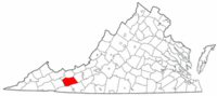 Wythe County was formed on 1 May 1790 from the southwestern section of Montgomery County. It was named for George Wythe, a signer of the Declaration of Independence and chancellor of Virginia in 1789 when the county was formed. In 1793 the first of several partitions occurred, with Grayson being formed from Wythe territory. Tazewell followed with a portion of Wythe in 1800. In 1808 a part of Wythe was added to Giles County. In 1824 a part of Grayson County was added to Wythe County. In 1826 the section of Poor Valley in Wythe was given to Tazewell. In 1832 Smyth County was formed in part from Wythe; and in 1839 Pulaski County was formed in part from Wythe. In 1861 Part of Bland County was taken from Wythe, and in 1862 one house and plantation was transferred from Wythe to Pulaski County. At that point, Wythe achieved its current bounds.
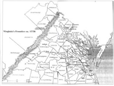 WOLF HUNTERS ON THE VIRGINIA FRONTIER, 1776-1818 [bounty lists & certificates from Amherst, Augusta, Bath, Botetourt, Grayson, Greenbrier, Hampshire, Hardy, Mopntgomery, Patrick, Pendleton, Rockbridge, Russell, Shenandoah, Washington, and Wythe counties [dates vary] transcribed & edited by Karen Wagner Treacy. 8 1/2 x 11, vi, 169 pages, full name index.
  Wythe Co. 1815 Directory of Landowners
by Roger G. Ward. 2005. 24 pages, map, 5 1/2X8 1/2.
Wythe Co. 1815 Directory of Landowners
by Roger G. Ward. 2005. 24 pages, map, 5 1/2X8 1/2.