Iberian Publishing Company's On-Line Catalog: Lunenburg County Virginia
Lunenburg was formed in 1745 from the western portion of Brunswick County. It named reflected one of the titles of King George II, who was also the Duke of Brunswick-Lunenburg in the German states. In 1753 Halifax County was created from the southwestern part of Lunenburg, and the following year, 1753, Bedford County was established from the northwestern portion. Another addition from Lunenburg to Bedford came in 1754, when land west of the mouth of Falling River was given to the latter. In 1764 both Charlotte and Mecklenburg counties were created from Lunenburg land, and in 1777 a part of Charlotte's holdings were returned to Lunenburg. Lunenburg County achieved its present boundaries at that time.








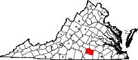 Lunenburg was formed in 1745 from the western portion of Brunswick County. It named reflected one of the titles of King George II, who was also the Duke of Brunswick-Lunenburg in the German states. In 1753 Halifax County was created from the southwestern part of Lunenburg, and the following year, 1753, Bedford County was established from the northwestern portion. Another addition from Lunenburg to Bedford came in 1754, when land west of the mouth of Falling River was given to the latter. In 1764 both Charlotte and Mecklenburg counties were created from Lunenburg land, and in 1777 a part of Charlotte's holdings were returned to Lunenburg. Lunenburg County achieved its present boundaries at that time.
 LUNENBURG CO., VA 1810 CENSUS transcribed by John Vogt. 10 1/2 x 8 1/2, x, 38 pages, illustrations, maps. This is the first surviving
census for Lunenburg, since both the 1790 and 1800 censuses have been lost. Lunenburg was a populous county in Southside Virginia, with moderate-sized plantations and a significant slave population (60%). In
addition to the census, the transcriber has correlated the names on the census with those of the 1815 landowners in Lunenburg. 1815 was the first year in which the owner's land was delineated in relation to its distance and direction from the courthouse. In this manner, groups of settlers may be ascertained and family groups defined.
LUNENBURG CO., VA 1810 CENSUS transcribed by John Vogt. 10 1/2 x 8 1/2, x, 38 pages, illustrations, maps. This is the first surviving
census for Lunenburg, since both the 1790 and 1800 censuses have been lost. Lunenburg was a populous county in Southside Virginia, with moderate-sized plantations and a significant slave population (60%). In
addition to the census, the transcriber has correlated the names on the census with those of the 1815 landowners in Lunenburg. 1815 was the first year in which the owner's land was delineated in relation to its distance and direction from the courthouse. In this manner, groups of settlers may be ascertained and family groups defined. SOME EARLY LANDOWNERS IN SOUTHERN NOTTOWAY AND NORTHERN LUNENBURG COUNTIES, VIRGINIA AND THE COCKE (COKE) FAMILY WHO ONCE LIVED THERE
by Ben H. Coke, 1997. 138 pages, maps, index. Ben Coke provides the reader with the ability to locate eighteenth-century residents of this are
in a number of ways: through the tract itself, where the tract, year, grantor, grantee, acreage,
and source are listed; through an alphabetic listing of grantees with the same essential
information; and a listing of grantors; In addition, there are a number of topographic maps, plus
name and plat indices at the end. Anyone with early landowning colonial family in the region
will welcome this study.
SOME EARLY LANDOWNERS IN SOUTHERN NOTTOWAY AND NORTHERN LUNENBURG COUNTIES, VIRGINIA AND THE COCKE (COKE) FAMILY WHO ONCE LIVED THERE
by Ben H. Coke, 1997. 138 pages, maps, index. Ben Coke provides the reader with the ability to locate eighteenth-century residents of this are
in a number of ways: through the tract itself, where the tract, year, grantor, grantee, acreage,
and source are listed; through an alphabetic listing of grantees with the same essential
information; and a listing of grantors; In addition, there are a number of topographic maps, plus
name and plat indices at the end. Anyone with early landowning colonial family in the region
will welcome this study. 1815 DIRECTORY OF VIRGINIA LANDOWNERS & GAZETTEER, vol. 2 South Central Region
(Includes the counties of Bedford, Brunswick, Campbell, Charlotte, Franklin,
Greensville, Halifax, Henry, Lunenburg, Mecklenburg, Patrick, Pittsylvania, Prince Edward, Southampton, and Sussex) abstracted by Roger G. Ward. 1997, vi, 234 pages, indices, maps.
1815 DIRECTORY OF VIRGINIA LANDOWNERS & GAZETTEER, vol. 2 South Central Region
(Includes the counties of Bedford, Brunswick, Campbell, Charlotte, Franklin,
Greensville, Halifax, Henry, Lunenburg, Mecklenburg, Patrick, Pittsylvania, Prince Edward, Southampton, and Sussex) abstracted by Roger G. Ward. 1997, vi, 234 pages, indices, maps.
 Lunenburg Co. Revolutionary Public Claims
transcribed by Janice L. Abercrombie and Richard Slatten.. 2005. 27 pages, 5 1/2X8 1/2.
Lunenburg Co. Revolutionary Public Claims
transcribed by Janice L. Abercrombie and Richard Slatten.. 2005. 27 pages, 5 1/2X8 1/2.


