 WOLF HUNTERS ON THE VIRGINIA FRONTIER, 1776-1818 [bounty lists & certificates from Amherst, Augusta, Bath, Botetourt, Grayson, Greenbrier, Hampshire, Hardy, Mopntgomery, Patrick, Pendleton, Rockbridge, Russell, Shenandoah, Washington, and Wythe counties [dates vary] transcribed & edited by Karen Wagner Treacy. 8 1/2 x 11, vi, 169 pages, full name index.
Locating an ancestor on the Virginia frontier in the late colonial and early republican period can be a daunting task. As the historian and archivist Robert Clay once remarked in a lecture, an individual he was researching in Virginia’s frontier region "appeared in a random document one morning, fully grown, and disappeared the following morning never to be heard from again.”
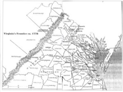
Oftentimes, early frontiersmen created few records and left little trace of their passing. Nowhere is this more evident than in the rapidly changing frontier west of the Blue Ridge. Starting with a trickle of settlers, there probably were no more than 160 families residing west of the mountains by 1735. By 1776 and the American Revolution, the number of settlers had grown to tens of thousands, attracted by the rich soils and pasture lands of the Shenandoah Valley and beyond, into Kentucky.
As the new government sought to bring order to the region, parent counties like Augusta and Lunenburg, which originally were little more than artificial lines when first drawn by surveyors in the wilderness, underwent division and subdivision into smaller political units to accomodate the new settlers. The trio of counties on Virginia’s frontier in the early 1740s [Frederick, Augusta, Lunenburg] would be divided and further subdivided over the next seven decades into more than sixty political units.
Author Karen Treacy has discovered an enlightening and unexpected record in the bounty system for wolf hunters. Early farmers and herders sought legislative relief from the scourge of wolf packs. The Virginia legislature responded by establishing the bounty system. In a time when an average laborer’s earning was $6-10/month, the $1 to $6 or 100# tobacco from a wolf scalp (depending on the currency and inflation of the time) was an attractive economic draw for every class of frontiersman, even those constantly moving folk mentioned by Clay.
This book is an important record not only for the two and a half thousand individuals cited but also for a valuable historical window into the activities and growth of Virginia’s frontier society.
To view a digital copy (pdf) of the index to this book, visit Index-Bounty Lists
(Close the pdf file with the left arrow to return to Iberian's catalog)
[WOLF] $34.95
 HARDY COUNTY, VA 1810 SUBSTITUTE CENSUS [Abstracts from the 1810 Personal Property Tax List]
by John Vogt, 2011, 5 1/2"x8 1/2" format, viii, 11 pages, map.
HARDY COUNTY, VA 1810 SUBSTITUTE CENSUS [Abstracts from the 1810 Personal Property Tax List]
by John Vogt, 2011, 5 1/2"x8 1/2" format, viii, 11 pages, map.
Hardy is one of eighteen Virginia counties for which the 1810 census is lost. In August, 1814 British troops occupied Washington, DC and public buildings were put to the torch. In the destruction that followed, numerous early records of the government were lost, including all of Virginia's 1790 and 1800 census reports, as well as eighteen county lists for the state's most recent [1810] federal census. Although two "fair copies" of each county's census had been left in the counties for public display, these were ephemeral lists and not preserved, and by 1814 they too had been mislaid, lost, or destroyed. Hence, the closest document available we have to reconstruct a partial image of the missing county lists is the personal property tax list.
According to research notes by Minor T. Weisiger, Library of Virginia archivist:
"Information recorded in Virginia personal property tax records changed gradually from 1782 to 1865. The early laws required the tax commissioner in each district to record in "a fair alphabetical list" the names of the person chargeable with the tax, the names of white male tithables over the age of twenty-one, the number of white male tithables between ages sixteen and twenty-one, the number of slaves both above and below age sixteen, various types of animals such as horses and cattle, carriage wheels, ordinary licenses, and even billiard tables. Free Negroes are listed by name and often denoted in the list as "free" or "FN."
The present abstract of Hardy's 1810 personal property tax list is NOT a transcript of the entire document; rather, it is a summary of three items important in delineating the 1810 "substitute" census for this county, i.e., number of male tithables 16 and older, number of slaves twelve years and older, and the number of horses. The original form of the census was in alphabetic order by date and letter. The substitute list presented here is in absolute alphabetic order for easy reference.
In the current volume, the data is recorded thus:
Beck, Robert 1 - 2
Bellama, John 1 - 1
Booker, Richard E. 1 - -
Bouldin, Green 2 6 5
Column one represents the tithable males (16 and over) in the household; column 2 is the number of slaves over 12; and the final column is the number of horses, mares or mules.
For genealogical researchers in this 1810 period, personal property tax records may provide additional important information. Oftentimes, juniors and seniors are listed adjacent to one another and recorded on the same day. When a taxpayer is noted as "exempt", it can be a clue to someone holding a particular position in government or being elderly, infirm, or for some other reason no longer required to pay the tithable tax. Women, both black and white, appear occasionally as heads of households when they own property in their own right or as the widow of a property owner.
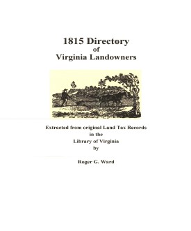
Another valuable source for filling in information about an ancestor is the land tax record, and especially the one for 1815. In that year, the enumerators began to add the location of the property in relation to the county court house. Roger Ward has abstracted all of the 1815 land tax records, and they are available from this publisher at www.iberian.com.
The 1810 substitute census list for Hardy County contains 811 households, 962 tithables, both white and free black, and 422 slaves over the age of twelve, and 3,226 horses.
Surname list
[HRDYPP] $4.50 (printed version)
The above title is also available as a digital e-book in PDF format:
[EHRDYPP] $3.00 (electronic version version)
 Hardy Co. 1815 Directory of Landowners
by Roger G. Ward. 2005. 22 pages, map, 5 1/2X8 1/2.
Hardy Co. 1815 Directory of Landowners
by Roger G. Ward. 2005. 22 pages, map, 5 1/2X8 1/2.
For a full description of the 1815 LAND DIRECTORY Records and a listing of available counties, see:
Individual County Booklets, 1815 Directory of Virginia Landowners
[Vd39] $7.00
The above title is also available as a digital e-book in PDF format:
[EVd39] $4.50 (electronic version)
For records pertaining to HARDY COUNTY, VIRGINIA see:


Please see our HELP PAGE for mail-order instructions, wholesaler policies and other contact information.
|| Virginia/W.Va. || General Reference || Military Records ||
|| Other States || E-Books || New Titles || Home Page || E-Books ||
Copyright 2026 Iberian Publishing Company


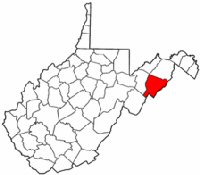 Hardy County was formed in 1785 from the southern territory of Hampshire County and named for Samuel Hardy, a Virginia statesman of the period. In 1787 a small parcel was returned to Hampshire County, and in 1788 another parcel was cut off to form the northern part of Pendleton County. Grant County was formed from the western lands of Hardy in 1866.