Augusta County, Virginia Delinquent Tithable Lists, 1771-1817 (with others from its former territories)
Karen Wagner Treacy, 2023, viii, 152 pp., index.
A portion from the author's Introduction is reproduced here:
In the late 1700s and after, the expense of governing Virginia's counties was raised by taxes collected by the sheriffs and their deputies. Lists of taxpayers, also called tithes, often contained remarks on individuals who were unable, for various reasons, to pay the taxes. Deputies returned lists of those delinquents to account for their failure to produce the full amount of tax. People appeared on these delinquent lists for a variety of reasons: they were dead, in the penitentiary, removed, run away, or insolvent. Another reason was that they were classed as supernumeraries. Those were men who had been exempted by the Court from taxation, usually for reasons of age or demonstrated infirmity. I suspect constables, as officers of the Court, were exempt as a perk of their position, as were men serving in the military. Occasionally information was recorded about the individual's occupation (to distinguish between men of the same name), generational status, or new location. Some women were named as heads of household, some names were identified as (free) blacks.
Most of this volume are the delinquent tithable lists found in the holdings of the Library of Virginia, Barcode number 1204934: Tax and Fiscal Records (1771-1833), a portion of Augusta County (Va.) Court Papers, 1769-1837. A finding aid describes these records in greater detail (at https://ead.lib.virginia.edu/vivaxtf/view?docId=lva/vi04145.xml). Boxes 1, 2, and 3 of those Papers are records of the Overseers of the Poor: Boxes 1 and 2 (covering the period 1769-1811) are transcribed and published in a separate volume. A third in this series is the transcription of the second portion of the Vestry Book of Augusta Parish, for the period 1759-1780, which is catalog item 20429, Vestry book, 1746-1782, Augusta Parish (Augusta County, Va.). It deals with (among other issues) insolvent residents assisted by the vestry, before the establishment of the Overseer of the Poor system in 1781. The first portion of that record, 1747-1759, has been transcribed in a very useful Master's thesis by John Logan Anderson at the University of Virginia, entitled The Presbyterians and Augusta Parish, 1738-1757: a political and social analysis, 1985.
In the interest of keeping this study to a reasonable scope, I did not transcribe Box 3 of the overseer records, from 1812 to 1837. For the same reason, I truncated the later delinquent tithable lists: there is a natural gap between the lists for 1817 and the resumption of lists from 1829 to 1833; I have not included those later lists in this volume.
Thematically, this is part of a three volume series. I hope to shed light on impoverished and under-documented residents in the general area of Augusta County. The inclusion of a name in these records is not indicative of criminal delinquency; poverty is not delinquency, after all, and many criminals are better documented than some of these impoverished men and women. As for the reasons these names appear on these lists, many had moved to another location and would have been taxed there. Other recurring individuals appear as 'insolvent', 'too poor to pay', etc, and show up elsewhere on the parish lists as recipients of public charity. Some women on those poor rolls may have been widows of some of the insolvent men here.
As a matter of context, some of the earliest lists in this present volume are not from what is presently Augusta County; but from counties formed from the vast territory of its original boundaries. Botetourt County was formed from in it 1770, and Fincastle County was formed from Botetourt in 1772, and was in turn absorbed by Montgomery County in 1775. Three Fincastle lists are Library of Virginia catalog items 1) barcode 28547 List of delinquents in that part of Fincastle County settled on the waters of Clinch River, compiled by Henley Moore; 2) barcode 28548 List of delinquents returned by James McGavock for 1773; and 3) barcode 28549 List of delinquents returned by Daniel Trigg, deputy sheriff, for the year 1773. These items were copied from Montgomery County papers (Accession 23680). Catalog item GLR05074, not copied, is an affidavit, by Henry Ewin, Clerk, of Rockingham County, from March 1784 regarding Captain Benjamin Harrison's list of delinquents, it is available at the Library of Virginia on microfilm Misc Reel 2979. Rockingham was created in 1778 from a northern part of Augusta County. Other additional delinquent lists are from Library of Virginia catalog item APA 427a, Augusta County, delinquent taxes, 1788-1796, Virginia, Auditor of Public Accounts (1776-1928), which includes the document concerning the sheriff's prosecution, below.
To view a digital copy (pdf) of the index to this book, visit Index-Acdt
(Close the pdf file with the left arrow to return to Iberian's catalog)
[Acdt] $30.00 (printed version)

 Augusta District, Virginia, Court Records, 1789-1791 (of the District composed of the Counties of Augusta, Rockbridge, Rockingham & Pendleton)
Karen Wagner Treacy, 2022, iv, 335 pp., index.
The author's Introduction is reproduced here:
It started with a dead body found in a cave. Rumors of grave-robbing came to the coroner's jury. Unacceptable comments on race were made and published. Mutual suits for slander were filed. Typical days for the Augusta County District Court?
It nearly was. While the above suit and countersuit between Alexander Humphreys and Michael Garber (beginning on page 164) is the most spectacular account in this volume, it is far from being the only scandal. In 1786 the papers in the office of Richard Madison, late Clerk of Court, were found to be in such disarray that his estate was sued for the cost of refiling them. In 1791 Sheriff Thomas Hughart was prosecuted for perjury for understating the amount of taxable property on the county rolls. Papers filed in that case (beginning on page 159) include both Hughart's list of taxables and the auditors version of the same.
There are suits about violent assaults ("after much disputing Mr Yeager flew to his Gun and snapt it at sd Evans that he the sd Evans seized the Gun and Bringing the Gun down struck Yeager on the forehead so as the Skin hung down over his eye" page 298) and vicious slander (page 182 "these false scandalous & defamatory words following that is to say she the said Mary meaning may perhaps not be with child at this time but the reason of it is that she ye said Mary meaning has made away with it meaning that she ye said Mary had been pregnant with a bastard child & had destroyed or murdered it ye said child") and extravagant language in general ("the sd Deft knowing the premises and greatly envying the happy state and condition of the said Alexander and contriving and maliciously intending the sd Alexander in his good name fame condition and reputation to hurt, injure, degrade and him in his Business aforesd to prejudice and damnify and to cause the sd Alexander to be esteemed and reputed a person guilty of Murder" page 273). Drama, faded to a rusty brown ink, still adheres to these pages.
The bulk of cases coming before the District Court were for debt. Many cases summarized in my earlier volume of Augusta District Virginia Court Records 1789-1797, New Papyrus Publishing, Athens GA, 2019, (hereafter Augusta District) appear in this one in greater detail. This present volume covers 1789-1793 and is a companion volume to the previous record. There is much overlap: this volume covers fewer cases but in greater detail and includes supporting documentation.
Some of the entries have quite interesting economic data. Several cases reference the severe inflation that took place as a result of the Revolutionary War. The Scale of Depreciation is mentioned, in October of 1780 it is specified as being Seventy three for one. An amount stated in the currency of another state is annotated with its value in Virginia currency. Many promissory notes require payment in gold or silver. The customary units are pounds, shillings, and pence, but dollars and other coinage are also mentioned. It is noted that the penal sum built into contracts is double the contracted amount (page 87), and that the penal for retarding execution of damages (by filing an appeal) is ten percent (page 122 and 253).
A lawsuit over the construction of a mill includes a very detailed list of parts and labor (page 104). A Richmond merchant supplying a Staunton merchant gives us an equally detailed view of items stocked in the Staunton store, and local produce shipped to Richmond (page 124). A suit in 1791 mentions the timber value of various trees illegally cut on the plaintiff's land (page 281). Notes of obligation were frequently reassigned as a form of currency, usually for 'value received' but at least once as the result of a bet on a horse race (page 270).
Slaves and slavery appear in many cases. They figure in failure to complete contract suits and more acrimoniously in suits arising from slaves given in wills or marriage portions. A will quoted on page 186 says "And first I leave and bequeath unto my beloved Wife Agness I leave and bequeath my Dwelling house and my Molatta Wench and ... two Mares one known by the name of Phenix and the other Munsey." Note the wife and the mares are identified by name. Slaves also had a tendency to become 'lost' and come into the possession of someone else 'by finding', generally on the same day, and lawsuits attempted to sort out the ownership. The soundness of a convict servant man (page 200) is argued in the same way as slaves are required to be sound.
Still, it is the cases with sexual implications that catch the attention. A jury in a breach of promise suit gave judgement for the woman. The man appealed the two hundred pounds damages to the higher court in Richmond (page 66). On page 152 a man sued for being accused of buggery, on page 91 a woman was tried and acquitted of infanticide. A man was slandered by an accusation of rape, alleging he came in through the bedroom window while the husband of the house was out fishing (page 202).
Women did demonstrate some independence in certain cases. Mary Devericks maintained her right to select her own 'next friend' to defend her from slander as she was unable due to her age to represent herself (page 273). Mary Teas undertook as Special Bail for John Reid that if he were cast (lost) in the case he would "Satisfy the Condemnation of the Court or Render his Body to prison in execution for the same" or else Mary Teas would do it for him (page 228).
The Revolution made little explicit impact in these pages. I found the use of 'Washington's birth night' as a calendar reference in 1789 interesting (page 98). In 1775 a Richmond merchant wrote " I wonder what their mad associations will come I am giddy when I think about the dispute it is too ardous a matter almost to think of. I wish they had taken more compleat methods" (page 139). Virginia was still called a 'Collony' in 1786 (page 55).
As a person with some experience trying to decipher old records, I sympathize with Andrew Reid copying records from 1746: "The above is a true copy so far as the original Deed can be Read it being shattered and worn so that the Clerks Name is entirely afaced" (page 84). It is not the fault of the clerks that I could not decipher Germanic names, but I included the images in hopes someone else can read them. The orthography of this volume was overall of high quality. The dramatic content was higher still.
To view a digital copy (pdf) of the index to this book, visit Index-Adcr2
(Close the pdf file with the left arrow to return to Iberian's catalog)
[Adcr2] $37.95 (printed version)
Augusta District, Virginia, Court Records, 1789-1797 (of the District composed of the Counties of Augusta, Rockbridge, Rockingham, Pendleton and Bath)
Karen Wagner Treacy, 2019, viii, 272 pp., index.
Some examples from the author's Introduction are reproduced here:
The Court met twice a year, in April and September, in the Courthouse at Staunton, in Augusta County.
For finicky detail, this may possibly be the most challenging volume I have transcribed. One entry alone (page 34 of original manuscript) contained 41 names. I have done my best to reproduce the text as it is written, misspellings and all. For the index I adopted one standard spelling, as far as I could be reasonably sure that the entries referred to the same person. However, do check also other probable spellings. I am certain I have misread many names. Sorry. Quantum in me fuit!
Many of the cases were sent up from their respective county courts, but many were filed here as the court of origin. Unless agreed by the parties or dismissed by the plaintiffs, very few were settled at the first hearing. Most carried on from court to court, being continued even in spite of a jury verdict upon an appeal for a new trial. This makes the material in this volume quite repetitive. I have edited some entries, to remove the 'boilerplate' and focus on what really happened. All names have been retained, of course. Where I have omitted or abbreviated material, the summary is given in square braces. I shall give here, in the introduction, examples of the terminology which is repeated over and over.
An example from the beginning of page 12:
John McClery Plt
against In Debt
James Hawthorn & James Scott Defts
This day came as well the plt by his Attorney as William Scott Security for the Deft James Scott by his attorney, and There upon came also a Jury to wit Mathew Gamble, James Montgomery, Adam Bratton, James Hogg, John Bradshaw, James Knowls, Joseph Bell, James Guy, Joshua Parry, James Divier, George Benson and Edward Erwin who being elected tried and sworn the truth to speak upon the issue joined upon their oath do say that the said Deft hath not paid the Debt aforesaid as the plt in replying hath alledged, and they do assess the plts Damages by occasion of the detention of the said Debt to one penny besides his Costs. Therefore it is considered by the Court that the plt recover against the said Deft James Scott and William Scott his Security aforesaid Three hundred and one pounds eight Shillings, the debt in the declaration mentioned and his damages aforesaid in form aforesaid assessed, and his Costs in this behalf expended & the said Deft in Mercy &c.
But this Judgment is to be discharged by the payment of One hundred and three pounds two Shillings, with Interest on One hundred and fifty pounds fourteen Shillings to be computed after the rate of five per centum per Annum from the twenty third day of September 1784 'til the eighth day of August 1785 and then on one hundred and Ten pounds two shillings 'til the 27th day of September 1785, and then on One hundred and three pounds two shillings 'til paid and the Damages aforesaid and the Costs.
From pages 240-241:
– Aminidab Seekright plt
against In Ejectment for one tenement one Garden & one lot of land in the Town of Staunton known by the number Ten containing half an acre of arable Land on Water Street with the appurtenances lying & being in the County of Augusta of the Demise of Michael Fackler and Jacob Geiger
Ferdinando Dreadnought Deft
This day came the plaintiff by his attorney and on the motion of William Chambers by his attorney he is admitted defendant in this suit in the room of the said Dreadnought, pleads the general Issue, confesses the lease entry & ouster in the declaration supposd & enters into the common rule to insist only on the title at the trial. Wherefore the conditional Judgment obtained by the pltf in this cause is set aside & this suit is ordered to be continued until September Court next. And on the motion of the plaintiff by his attorney It is ordered that the Surveyor of Augusta County do go upon the Lands in controversy on the next Saturday after the third Tuesday in May next if fair, if not then on the next fair day, and survey and lay off the same as each party may require & return three fair platts & reports of the same to the Clerks office (page 241) sometime before September Court next, and that Alexander St Clair & Alex'r Humphreys Gentlemen Justices of the peace for the County of Augusta do then & there meet him and take the depositions of such witnesses as shall be produced on either side, which are to be returned with the said platts & reports and that the Sheriff of the said County attend the said Survey and remove force if any shall be offered.
In many cases concerning land title fictitious names are employed, such as Aminidab Seekright and Ferdinando Dreadnought. Others are Thomas Trytitle or Henry Goodtitle against David Notitle, or Soloman Saveall against Simpleton Spendall. As the case progressed, some individual would petition to be named the defendant in the case 'in the room' of the said Dreadnought or Spendall. If no one appeared to defend the case, the court would respond in this fashion.
From pages 21-22:
– Soloman Saveall plt
against In Ejectment for one plantation one messuage, one garden, & one hundred & thirty acres of land lying and being in the parish and county of Augusta of the demise of Joseph Malcom
Simpleton Spendall Deft
This day came the plt by his Attorney and it (page 22) appearing by the affidavit of Oliver McCoy that John Beveridge tennant in possession of the premises has been duly served with a Copy of the plts declaration and of the Note thereunder written, and the said John Beveridge not appearing, it is ordered that unless he having Notice of this order or those under whom he claims or some or one of them do appear here on the first day of April Court next and make himself herself or themselves Deft or Defts in this suit in the room of the said Spendall plead the General Issue, confess the lease, entry & ouster in the Declaration supposed, and enter into the common rule to insist on the title only at trial, Judgment shall be given for the plt and a writ of possession awarded him.
When a suit for possession was defended:
From page 97:
Aminidab Seekright plt
against In Ejectment for one plantation one messuage one garden and one hundred and fifteen acres of land in the County of Rockingham of the Demise of Andrew Cutler and Agness his wife & James Bowyer and Margaret his wife
Ferdinando Dreadnought Deft
Uriah Garton is on his motion admitted Deft in this suit in the room of the said Ferdinando Dreadnought and thereupon by Rich'd Stuart esq'r his Attorney comes and Defends the force and Injury, when and where the Court will consider thereof pleads the General Issue, confesses the lease entry & ouster in the Declaration Supposed and agrees to insist on the title only at the trial.
A person involved in a suit often was required to give security for his or her appearance or to guarantee financial liability. Usually this was the defendant, but not always. This was recorded in the following form:
From page 54:
William Chambers undertook that if the Deft be Cast in this suit he shall pay and satisfy the condemnation of the Court, or render his body to prison in execution for the same, or that he the said William Chambers will do it for him.
or (from page 431)
Robert Willson came personally into Court and undertook for the plaintiff that in case he be cast in this suit he will satisfy & pay the Defendant all such Costs & Damages as may be awarded against the s'd plff and that he will also discharge the officers fees due or to become due from the s'd plaintiff.
Punishments administered by the court were burning in the left hand for grand larceny (administered by the Jailer in the presence of the court, on several occasions) and hanging. Hanging was decreed for Elizabeth Hazle, in October 1791, for murder (the case originated in Rockingham County, where she was examined for suspicion of killing her base born child, see Chalkley), and for John Bullett, in October 1793, for horse stealing. The Sheriff of Augusta County was responsible for the executions. Two judges were present when hanging was ordered.
If the defendant was found not guilty of a major offense, that verdict was publicly announced.
From page 493:
The Commonwealth
against On a Commitment from the Examining Court of Rockingham County under a Charge of feloniously & forcibly making an Assault on Sally Olinger & by force & against her will having carnel knowledge of her Body
Jacob Goode Deft
This day Came the attorney prosecuting for the Commonwelth and the said Sally Olinger & Ann Good two of the witnesses for the Commonwealth not appearing tho' solemnly called & no good cause being shewn why this Cause should be continued the said prisoner was led to the Bar in Custody of the Keeper of the public jail, and thereupon proclamation being made as the manner is & nothing appearing or being alledged against him & is ordered that he be discharged from his imprisonment.
A typical exoneration by the jury is as follows:
From page 37:
Henry Miller Plt
against In Trespass
Samuel Erwin Deft
This day came the parties by their attornies and thereupon came also a Jury towit. John Tate, Peter Hanger, James Buchanan, James Johnston, James Megongal, Jonathan Reid, Robert Douthat, Matthew Gamble, Andrew Steele, Gilbert Christian, Anthony Mustoe, & Hugh McDowell, who being elected tried and sworn the truth to speak upon the issue joined upon their oath do say that the Deft is not guilty of the Trespass in the declaration Mentioned, as in pleading he hath alledged. Therefore it is Considered by the Court that the plt take nothing by his bill but for his false clamour be in mercy &c. And that the Deft go thereof without day and recover against the said plt his costs by him about his defence in this behalf expended.
Fines for non-attendance for jury duty were imposed as follows.
From page 5:
– Alexander Gibson, John Brown, Peter Hanger & James Brown of the County of Augusta, and John Bowyer, Alexander Stuart & Andrew Moore of the County Rockbridge, who were summoned to appear here this day as Grand Jury men were severally solemnly called but came not. Therefore it is considered by the Court, that for their said contempt they severally make their fine with his Excellency Beverley Randolph esquire Governor or chief Magistrate of this Commonwealth, and his successors, for the use of the Commonwealth, by the payment of four hundred pounds of Tobacco each, unless they shall shew sufficient cause of their inabillity to attend at the next Court.
Later, the standard fine for non-appearance was eight dollars.
Monetary fines and damages were usually in pounds, shillings, and pence, but sometimes in dollars, and occasionally in tobacco. When interest was ordered it was always at five percent except for out of state obligations, where it followed the legal rate of that state.
Only a few entries take note of current events.
From pages 499:
On the motion of the Defendants by their attorney a Dedimus is awarded them to take the Depositions of Thomas Turk & Robert Craig who are affraid to attend the Trial on account of the small pox.
I rather enjoyed the tavernkeeper on page 455 when he gently put his hands on the Defendant to put him out of his Tavern where he was breeding a riot & disturbing the peace of the House. Unfortunately the jurors decided against him. I am curious why Michael Garber gave testimony by affirmation (page 175), the only such instance in the record.
Those researching family history will find a few of the controversies over land to contain a surprising amount of family relationships. See entries for Mary Teas, Hugh Divier, and Robert Reed, for example. These records may also be helpful in establishing a death date. For convenience, I have added a section to the index of occasions where a cause abated (or a motion was made to have this occur) because of the death of one of the participants. Marriages are also mentioned such as Sampson Mathews & Cathrine his wife late Cathrine North, or James Beaty & Isabella his wife late Isabella Paul, Esther, Jane & Jenny Paul, Heirs of John Paul sen'r dec'd.
Some entries of particular interest follow the slave Robert Nailor, who petitioned for permission to sue his master for his freedom. An attorney was appointed for Nailor, who sued his owner, Samuel Meek, for assault and battery and false imprisonment. Meek was ordered not to sell or mistreat Nailor while his case was under adjudication, and was in fact brought up on contempt charges for doing so. The case came up on several occasions, but was not settled within the pages of this volume, being repeatedly continued as Nailor sought depositions from witnesses in other counties. Later Nailor was addressed as being in the possession of James Cochran, who was ordered to produce him in court, and to provide assistance in obtaining depositions. I wish I knew how this turned out.
That's the way it is with many of the cases here. We see the legalities, but not the story behind them. Why did Samuel and Jane Estill sue repeatedly to eject her mother from her land? Why did George Benson and Thomas Feemster have such a confrontation about stolen butter? Why did Sally Olinger not follow through with her charge of rape? Why did the Justices of Pendleton County sue their Clerk of Court? We only wade through 526 pages of suits and countersuits because beyond the facts of the cases we glimpse the people and personalities.
To view a digital copy (pdf) of the index to this book, visit Index-Adcr
(Close the pdf file with the left arrow to return to Iberian's catalog)
[Adcr] $35.00 (printed version)
 MASSANUTTEN: SETTLED BY THE PENNSYLVANIA PILGRIM (1726) by Harry M. Strickler.
2024 (facsimile reprint of the 1924 edition, 182 pp.
MASSANUTTEN: SETTLED BY THE PENNSYLVANIA PILGRIM (1726) by Harry M. Strickler.
2024 (facsimile reprint of the 1924 edition, 182 pp.
A facsimile reprint of a classic work. Harry Strickler weaves extensive research and primary sources into a tale which opens the lives of the colonial settlers to the reader. This group of Pennsylvania Swiss and German pioneers established the first European settlement west of the Blue Ridge. Strickler explores the cultural and social dynamics of the early settlers, including their religious beliefs, customs, and traditions. Along the way he provides the reader with details that only an on-the-site observer and direct descendant could give. Lots of genealogical information, and a good read!
To view a digital copy (pdf) of the index to this book, visit Index-Msnt
(Close the pdf file with the left arrow to return to Iberian's catalog)
[Msnt] $25.00
The above title is also available as a digital e-book in searchable PDF format:
[EMSNT] $15.00 electronic version
 THE CAMPBELL CLAN IN VIRGINIA Campbell, Leslie Lyle. xii, 154 pages, 1954 Reprinted by Iberian Publishing Co., 2018.
Any researcher in Virginia genealogy with a Campbell ancestor is painfully aware of the difficulties involved in sorting out their family line from the myriad branches of the clan, many with similar given names (William, Alexander, Angus, just to note a few) that repeat themselves over countless generations. Leslie Lyle Campbell's early work provides a starting point for one of the major branches of the Campbell clan that settled throughout Virginia, especially in the Valley Region stretching from the Potomac deep into the southwestern corners of the state.
THE CAMPBELL CLAN IN VIRGINIA Campbell, Leslie Lyle. xii, 154 pages, 1954 Reprinted by Iberian Publishing Co., 2018.
Any researcher in Virginia genealogy with a Campbell ancestor is painfully aware of the difficulties involved in sorting out their family line from the myriad branches of the clan, many with similar given names (William, Alexander, Angus, just to note a few) that repeat themselves over countless generations. Leslie Lyle Campbell's early work provides a starting point for one of the major branches of the Campbell clan that settled throughout Virginia, especially in the Valley Region stretching from the Potomac deep into the southwestern corners of the state.
[Cciv] $15.00 (paper version)
The above title is also available as a digital e-book in PDF format:
[ECCIV] $9.00 (electronic version)
 Augusta County,Virginia 1810 Federal Census: A Transcription
John Vogt, 2008, revised 2013 ix, 56 pp., map, illus., arranged by rough alpha letter, 8 1/2 x 11 format, with an every-name index. The census includes separate lists for the rural county census as well as the communities of Staunton, Waynesboro, Greenville, and Middlebrook.
Census returns are some of the first records that a genealogist turns to when studying a new family line.
Unfortunately for Augusta County, as well as Virginia as a whole, both the 1790 and 1800 census reports for that state are lost. While the reason for their loss is argued, they nevertheless no longer exist. While personal property tax and land tax lists (which date from 1782) can be used to give some information about individuals, they do not give the researcher a glimpse into family composition or a snapshot of the county as a whole. Hence Augusta’s 1810 census is the first real window we have from the census records of this county which had been first settled in the early eighteenth century and whose original boundaries once stretched beyond the Ohio River. .
With the advent of the computer age and the publication of most of these early censuses, one would expect that many of the genealogist’s problems would be resolved. Unfortunately, this has not happened. While many researchers rely completely upon online census records, these are often flawed by misread names and missing names altogether. The problem is the difficult reading of the documents, which often are written in a tight, cramped hand and with a myriad of possible readings. The close similarity between “S’ and “L,” “F” and “T”, and recognizing the secretarial s, which appears as “ss” in the middle of words but not as an ending, can lead to nightmares in translation. Oftentimes, there is no distinction between an “e”, an “o”, and an “a” unless the reader is familiar with the family names within the document. These are only a few visual issues facing the transcriber. The author has been fortunate to have a professional background in paleography and history, both medieval and modern. In transcribing the current volume, comparison was made with other documents, as well as carefully examining each questionable character under magnification to ascertain the true intent of the writer. In the process, it became apparent that sometimes the census recorder himself was not familiar with strange-sounding German names or heavy Scottish brogues. One spelling would appear in the first encounter with the family, and then later on in the document a different spelling would be given for the same family surname. In brief, computerized lists, while useful, do not give a total and accurate picture of the data.
The census was recorded on one hundred folios in a small script, and herein lies the problem with “a”, “e” and “o” in the body of a name. Only by carefully examining the transitions between characters can an accurate reading be obtained.
To view a digital copy (pdf) of the index to this book, visit Index-1810-Augu
(Close the pdf file with the left arrow to return to Iberian's catalog)
[Ag10] $11.00 (printed version)
The above title is also available as a digital e-book in PDF format:
[EAg10] $7.00 (electronic version)
 FORERUNNERS: A HISTORY OR GENEALOGY OF THE STRICKLER FAMILIES, THEIR KITH AND KIN Strickler, Harry M., 1925. Reprinted by Iberian Publishing Co., 1998.
Harry Strickler's classic work on the Stricklers of the Shenandoah Valley is back in print. Included in this early work is material on not only on
the Stricklers, but also collaterial lines among the following families. Kauffmans, Stovers, Burners, Ruffners, Beavers, Shavers, Brumbachs, Zirkles,
Blossers, Groves, Brubakers, Neffs, Rothgebs, and many other early families of Shenandoah, Rockingham, Frederick, Augusta and Page Counties, Virginia.
FORERUNNERS: A HISTORY OR GENEALOGY OF THE STRICKLER FAMILIES, THEIR KITH AND KIN Strickler, Harry M., 1925. Reprinted by Iberian Publishing Co., 1998.
Harry Strickler's classic work on the Stricklers of the Shenandoah Valley is back in print. Included in this early work is material on not only on
the Stricklers, but also collaterial lines among the following families. Kauffmans, Stovers, Burners, Ruffners, Beavers, Shavers, Brumbachs, Zirkles,
Blossers, Groves, Brubakers, Neffs, Rothgebs, and many other early families of Shenandoah, Rockingham, Frederick, Augusta and Page Counties, Virginia.
To view a digital copy of the index to this book, visit Index-Fore
(Use your back arrow to return to Iberian's catalog)
[Fore] $32.00 (printed version)
The above title is also available as a digital e-book in PDF format:
[Efore] $20.00 (electronic version)
 NORTHERN NECK (LAND) WARRANTS & SURVEYS, 1730-1754: ORANGE & AUGUSTA COUNTIES, WITH TITHABLES, DELINQUENTS AND PETITIONERS by Peggy Shomo Joyner.
1985, xxv, 73 pp. Published as the first volume in a series of Northern Neck Warrants & Surveys, this collection has become a standard reference work for researchers in the period of colonial Augusta County history and that of its parent county, Orange.
NORTHERN NECK (LAND) WARRANTS & SURVEYS, 1730-1754: ORANGE & AUGUSTA COUNTIES, WITH TITHABLES, DELINQUENTS AND PETITIONERS by Peggy Shomo Joyner.
1985, xxv, 73 pp. Published as the first volume in a series of Northern Neck Warrants & Surveys, this collection has become a standard reference work for researchers in the period of colonial Augusta County history and that of its parent county, Orange.
The Northern Neck Proprietary – also called the Fairfax Proprietary, or Fairfax Grant – was a land grant first created by the exiled English King Charles II in 1649 and encompassing all the lands bounded by the Potomac and Rappahannock Rivers in colonial Virginia. This constituted up to 5,200,000 acres of Virginia's Northern Neck and a vast area northwest of it.
The grant became actual in 1660 when Charles was restored to the English throne. By 1719, these lands had been inherited by Thomas Fairfax, 6th Lord Fairfax of Cameron (1693-1781). By that time the question of the boundaries of the designated lands had also become highly contentious. It was decided in 1746 that a line between the sources of the North Branch of the Potomac and the Rappahannock River (the "Fairfax Line") would constitute the western limit of Lord Fairfax's lands. The early 17th century decade was witnessing a wave of pioneer settlement throughout the region.
To obtain land a person purchased a warrant from the proprietor’s agent specifying the precise location of the desired land. The warrant was then given to a surveyor, who surveyed the land. The plat, warrant, and any related papers were returned to the proprietor’s office, and if the title was clear, a grant was recorded and then issued. At any point after the warrant was purchased the land could be assigned (sold) to another person, and years could elapse between the purchase of the warrant and the issuance of a grant.
The volume is arranged first by county, then alphabetic by grantee. Please note: The index provided at the end of the volume contains only those persons whose reference occurs outside the alphabetic listing in the volume. It is NOT a complete index of names or places.
[Nnw1] $17.00 (printed version)
The above title is also available as a digital e-book in PDF format:
[ENnw1] $11.00 (electronic version)
ABSTRACT OF AUGUSTA COUNTY, VIRGINIA DEATH REGISTERS,1853-1896 Margaret C. Reese. 1983 (retypeset in new edition, 2015), vii, 204 pages,
introduction. The Death Registers of Augusta County, Virginia are complete except for
the year 1863 and the Pastures District, 1880 and 1888.
[Augd] $24.50 (printed version)
The above title is also available as a digital e-book in PDF format:
[EAugd] $15.00 (electronic version)
AUGUSTA COUNTY MARRIAGES, 1748-1850
John Vogt & T. William Kethley, Jr. 1986, ix, 414 pages, indices, figure, appendix, map. Augusta County was formed from Orange County in 1738 and originally encompassed all western lands of Virginia beyond the Blue Ridge Mountains and south of Frederick County. This volume
contains 5,244 marriage records (bonds, licenses, or ministers' returns).
Surname list
[Augu] $32.00 (printed version)
The above title is also available as a digital e-book in PDF format:
[EAugu] $20.00 (electronic version)
THE FEDERAL CENSUS OF 1850 FOR AUGUSTA CO., VA.
transcribed by Dorothy Lee Weaver. 1991, 404 pages, everyname index. The book includes
about 20,000 free inhabitants and is transcribed in the household order in which it was taken.
[AG50] $32.00
HERE LYETH: TOMBSTONE INSCRIPTIONS OF MOST CEMETERIES IN RIVERHEADS DISTRICT OF SOUTHERN AUGUSTA COUNTY AND STAUNTON, VA.
by Dorothy Lee Weaver. 1987, 288 pages, index, maps. The book includes
all cemeteries not previously published or recorded in the Riverheads District (including the areas of Middlebrook, Greenville, Newport and Steeles Tavern).
To view a digital copy (pdf) of the index to this book, visit Index-Here
(Use your back arrow to return to Iberian's catalog)
[HERE] $31.95 (printed version)
The above title is also available as a digital e-book in PDF format:
[EHere] $20.00 (electronic version)
 Augusta Co. 1815 Directory of Landowners
by Roger G. Ward. 2005. 40 pages, map, 5 1/2X8 1/2.
Augusta Co. 1815 Directory of Landowners
by Roger G. Ward. 2005. 40 pages, map, 5 1/2X8 1/2.
For a full description of the 1815 LAND DIRECTORY Records and a listing of available counties, see:
Individual County Booklets, 1815 Directory of Virginia Landowners
[Vd06] $9.00 (printed version)
The above title is also available as a digital e-book in PDF format:
[EVd06] $6.00 (electronic version)
 Augusta Co. Revolutionary Public Claims
transcribed by Janice L. Abercrombie and Richard Slatten.. 2005. 38 pages, 5 1/2X8 1/2.
Augusta Co. Revolutionary Public Claims
transcribed by Janice L. Abercrombie and Richard Slatten.. 2005. 38 pages, 5 1/2X8 1/2.
Surname list
For a full description of the Virginia Revolutionary Public Claims and a listing of available counties, see:
Revolutionary "Publick" Claims series
To view a digital copy (pdf) of the index to this book, visit Index-Augusta
(Close the pdf file with the left arrow to return to Iberian's catalog)
[Pc05] $6.00 (printed version)
The above title is also available as a digital e-book in PDF format:
[EPc05] $3.60 (electronic version)
For more records pertaining to AUGUSTA
COUNTY, VIRGINIA see also:
Guide to Virginia Militia Units in the War of 1812
Index to the 1810 Virginia Census
Chart on the Formation of Virginia Counties
Atlas of County Boundary Changes in Virginia, 1634-1895


Please see our HELP PAGE for mail-order instructions, wholesaler policies and other contact information.
|| Virginia/W.Va. || General Reference || Military Records ||
|| Other States || E-Books || New Titles || Home Page || E-Books ||
Copyright © 2026 Iberian Publishing Company


 This new county west of the mountains was named in honor of Augusta of Saxe-Gotha, Princess of Wales and mother of King George III. At the time of Augusta County's creation from Orange County in November, 1738 and its commencing to function as a separate entity in 1745, the new county technically included all of Virginia's land claims from the top of the Blue Ridge Mountains north, west and south. Today the area comprises more than twenty-one Virginia counties and most of the counties in West Virginia, as well as the state of Kentucky!
The first separation of territory from Augusta occurred in 1754 when the portion of Lord Fairfax's Northern Neck proprietary within Augusta's limits was transferred to Frederick County, thus making Augusta's boundary that of the western limits of the Northern Neck. The northern boundary fell along the present Rockingham-Shenandoah County border. Botetourt County was cut from Augusta lands in 1769 and included all of Augusta County south of a line run through the middle of Rockbridge and Bath counties. At some time before 1776, West Augusta District was created from Augusta's lands around Pittsburgh; in 1778 Illinois County was created from the land claimed by Virginia north of the Ohio River and technically a part of Augusta County. Further divisions of Augusta came with the creation of the new counties of Rockingham (1778), Rockbridge (1778), Pendleton (1788), and Bath (1791) until, following 1791, Augusta achieved its present size.
This new county west of the mountains was named in honor of Augusta of Saxe-Gotha, Princess of Wales and mother of King George III. At the time of Augusta County's creation from Orange County in November, 1738 and its commencing to function as a separate entity in 1745, the new county technically included all of Virginia's land claims from the top of the Blue Ridge Mountains north, west and south. Today the area comprises more than twenty-one Virginia counties and most of the counties in West Virginia, as well as the state of Kentucky!
The first separation of territory from Augusta occurred in 1754 when the portion of Lord Fairfax's Northern Neck proprietary within Augusta's limits was transferred to Frederick County, thus making Augusta's boundary that of the western limits of the Northern Neck. The northern boundary fell along the present Rockingham-Shenandoah County border. Botetourt County was cut from Augusta lands in 1769 and included all of Augusta County south of a line run through the middle of Rockbridge and Bath counties. At some time before 1776, West Augusta District was created from Augusta's lands around Pittsburgh; in 1778 Illinois County was created from the land claimed by Virginia north of the Ohio River and technically a part of Augusta County. Further divisions of Augusta came with the creation of the new counties of Rockingham (1778), Rockbridge (1778), Pendleton (1788), and Bath (1791) until, following 1791, Augusta achieved its present size.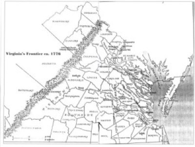 WOLF HUNTERS ON THE VIRGINIA FRONTIER, 1776-1818 [bounty lists & certificates from Amherst, Augusta, Bath, Botetourt, Grayson, Greenbrier, Hampshire, Hardy, Mopntgomery, Patrick, Pendleton, Rockbridge, Russell, Shenandoah, Washington, and Wythe counties [dates vary] transcribed & edited by Karen Wagner Treacy. 8 1/2 x 11, vi, 169 pages, full name index.
  THE FAIRFAX LINE
 Augusta Parish, Virginia Vestry Book, Part Two: 1768-1779
  Augusta County, Virginia Overseers of the Poor, 1770-1811
 Augusta County, Virginia Delinquent Tithable Lists, 1771-1817 (with others from its former territories)